Rocking up Late: The Advantages of Delayed AI Adoption for Lithium Producers
On the geology of hard rock lithium, the science of AI mineralogy, and why being a latecomer is not the disadvantage it appears to be.
GEOLOGYLITHIUM - SPECTRAL ANALYSIS, AI, TECHNOLOGY
Geostatagem Research, George Katito, PhD
3/25/202617 min read
In Brief
Countries like Zimbabwe that have not yet committed to first-generation AI exploration tools are not “behind”. They are positioned to adopt the next, more rigorous generation — one the scientific literature now shows is decisively more effective.
Lithium in hard rock does not always sit where the map suggests but where 2.6 billion years of geological history have placed it. AI systems that understand that history increasingly deliver high degrees of accuracy.
The real expertise gap is not about computing power. It is about the rare capacity to move fluently between rock science and machine learning. Closing it is an intellectual investment as much as a financial one.
There is a standard narrative about Africa and artificial intelligence. "The continent is behind". "It is falling further behind". "The urgent task is to close the gap". Applied to AI in lithium mining, this becomes: Zimbabwe lacks the computing infrastructure, the trained workforce, and the institutional frameworks that advanced mining economies have already built. This article argues that this framing is not only unhelpful — in an important and well-documented sense, it is wrong.
The peer-reviewed scientific literature on AI in mineral exploration has produced a finding that deserves more attention than it has received: the first generation of machine learning tools applied to mineral exploration was not as effective as widely claimed. A comprehensive review in Earth-Science Reviews — one of the most thorough surveys of AI in mineral exploration published to date — found that despite significant investment, the rate at which new mineral deposits are actually discovered in previously unexplored terrain has not improved (Yang, Zuo and Kreuzer, 2024).
The reasons are not necessarily only about computing power. Countries that invested early in these first-generation tools have built institutional and financial commitments to approaches that the scientific community is now revising. Zimbabwe has not made those commitments. The question is whether it and others can build something better.
What Makes Hard Rock Lithium Different
Mention lithium and most people picture the same thing: a vast, white salt flat at altitude somewhere in the Andes, geometric evaporation ponds catching the sun, a landscape so flat you can see the curvature of the Earth. That image — the South American salar — is accurate for one category of lithium. But it describes none of what lithium producers like Zimbabwe host.
Zimbabwe's hard rock lithium sits inside a class of rock called pegmatites — ancient, coarse-grained igneous rocks that formed deep underground when magma, pushed up through cracks in the Earth's crust, cooled very slowly and solidified over millions of years. The slow cooling is what gives pegmatites their distinguishing feature: unusually large crystals, sometimes big enough to hold in your hand. It is also what concentrates rare elements to extraordinary levels. Among those elements is lithium.
How Lithium Gets Into the Rock
Understanding how lithium ends up locked inside a pegmatite matters for AI, because it explains why the ore is where it is — and why any AI system that does not understand the process will struggle to find it reliably.
When magma begins to cool, the minerals that form first are the most chemically common ones — feldspar, quartz, pyroxene. As those minerals crystallise out and settle, the remaining liquid melt becomes progressively more concentrated in elements that do not fit easily into the crystal structures of common minerals. Lithium is one of those elements. So are cesium, tantalum, and rubidium. This progressive enrichment — the slow chemical distillation of a cooling magma — is called magmatic differentiation, and it is the fundamental process that creates lithium-bearing pegmatites (London, 2014).
The pegmatites that end up economically interesting are those enriched in all three of the elements lithium, cesium, and tantalum, so-called LCT pegmatites. These are the target of hard rock lithium mining worldwide (Bradley et al., 2017). A second, less common formation pathway involves the partial melting of existing crustal rocks, generating lithium-enriched melts from below rather than from a cooling surface intrusion (Koopmans et al., 2025). Both processes can produce the same economic result, but the geological signature they leave behind is different — which matters for exploration.
The specific lithium mineral that forms depends critically on the pressure and temperature at the point of crystallisation:
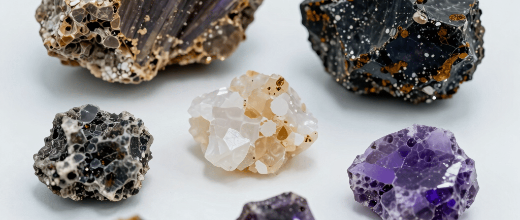
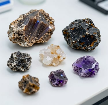
Spodumene — pale grey to white, with crystals that can grow to several metres in large bodies — forms at higher pressures, meaning greater depth. Petalite — milky white, glassy in appearance — forms at lower pressures and higher temperatures. Lepidolite, the lilac-coloured lithium mica that many people recognise from mineral collections, forms at the most chemically evolved, volatile-rich stage of crystallisation.
All three can occur in the same deposit. And the complexity does not end there: minerals can transform after formation — petalite breaking down into spodumene and quartz under later reheating, for instance — leaving a mineralogical record that reflects multiple episodes of geological change rather than a single frozen moment (Shaw et al., 2022).
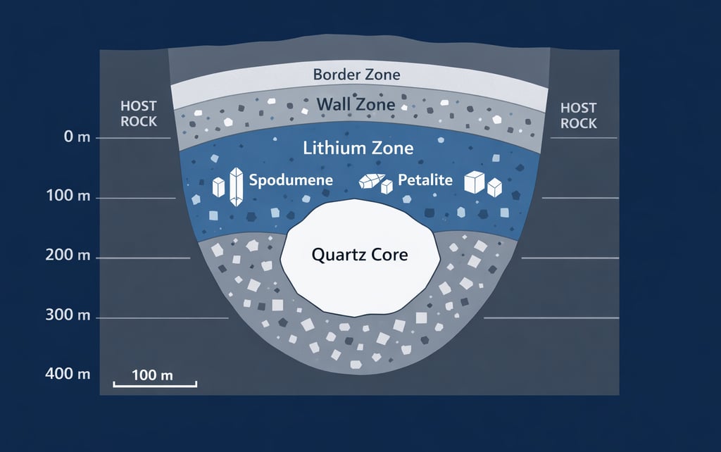
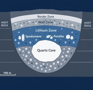
The Zonation Problem
The internal structure of an LCT pegmatite follows a broadly concentric pattern, working from the outside inward: a fine-grained outer margin, progressively coarser intermediate zones, a lithium-rich core region, and finally a mass of nearly pure quartz at the centre.
This zonation — described comprehensively by London (2014) — arises because crystallisation advances inward from the cooler margins, and the chemistry of the melt changes as each successive mineral phase forms and is removed from the liquid.
The important qualifier is that this textbook concentric model is a useful starting point, not a reliable template (Müller et al. 2019) . Many economically important spodumene deposits do not display classic internal zonation.
At some deposits, lithium mineralisation occurs in irregular pods and lenses whose distribution reflects geological events that happened long after the pegmatite originally formed — hydrothermal fluid circulation, tectonic deformation, or both. An AI system trained to recognise the concentric pattern will misidentify these deposits, and an AI system trained on one deposit type may perform poorly on another.
Zimbabwe's Ancient Platform and What It Contains
Zimbabwe's lithium deposits cannot be understood in isolation from the geological platform that hosts them. That platform — the Zimbabwe Craton — is one of the oldest and most stable pieces of continental crust on Earth. The word craton derives from the Greek for strength, and it is apt: these are the ancient, hardened cores of continents, long past the tectonic turbulence of their formation, and remarkably resistant to the forces that have repeatedly rearranged the rock around them.
A Continent's Old Core
The Zimbabwe Craton formed over a period stretching from roughly 3.5 to 2.6 billion years ago. Its oldest components — in the south of the country — preserve some of the most ancient rocks on the African continent (Jelsma et al., 2021). The dominant visible expression of that ancient history is the alternating pattern of greenstone belts and granite domes that anyone looking at a geological map of Zimbabwe will immediately recognise: long, narrow strips of dark volcanic and sedimentary rock, squeezed between rounded masses of lighter-coloured granite. Geologists describe this arrangement as dome-and-keel geometry, and it is a classic signature of late Archaean — meaning roughly 2.7 to 2.5 billion year old — crust on several of the world's older cratons (Kusky, 1998).
The stabilisation of the Zimbabwe Craton — the point at which it stopped being tectonically active and became the rigid basement it is today — occurred at approximately 2.6 billion years ago. The evidence is geological: a set of large, laterally extensive granites intruded across the entire craton at that time, and they are not deformed. Rock that intrudes while a terrain is still being deformed gets folded and sheared. These granites are flat-lying and coherent, which means the craton had already stiffened before they were emplaced.
Shortly after—around 2.575 billion years ago—a major body of magma was forced up from deep underground and solidified to form the Great Dyke: a ~550 km-long sheet-like intrusion of dense, dark, mafic rock ("mafic" referring to being relatively rich in iron and magnesium) that runs almost the length of Zimbabwe. The Great Dyke cuts straight across the craton without bending or being diverted, which shows that the underlying basement rocks had cooled and become rigid enough to carry tectonic stress by cracking rather than slowly warping and flowing around obstacles (Jelsma et al., 2021). It was within this long-lived, stabilised geological “platform” that Zimbabwe’s lithium-bearing pegmatites later formed.
The long history of erosion since stabilisation matters too. Over billions of years, the surface rocks above the craton have been gradually stripped away by weathering and erosion, exposing the mid-crustal levels where pegmatites were originally emplaced. Zimbabwe's lithium bodies are, in a real sense, rocks that have been brought to the surface by time. The same prolonged weathering that has exposed them has also created a chemically enriched soil zone above and around each deposit — a dispersal halo of lithium-indicator elements that is, as the next section discusses, directly exploitable by modern exploration methods.
The Four Fields: Why Each Poses a Different Problem
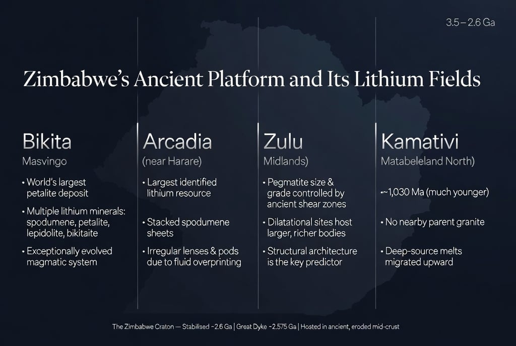
Zimbabwe has four principal lithium fields, and there are four genuinely different geological problems. This variety — often treated as simply a matter of economic scale — has profound implications for how AI exploration tools must be designed if they are to work in Zimbabwe.
Bikita in Masvingo Province is the oldest continuously worked lithium deposit in sub-Saharan Africa, with a production history stretching back to the early twentieth century. It is, by most assessments, the world's largest known petalite deposit.
What makes Bikita scientifically remarkable — and commercially complex — is the sheer variety of lithium minerals it contains: not just spodumene and petalite, but lepidolite, and a phase called bikitaite (a rare lithium aluminium silicate first described here and named for the locality) that appears at no other deposit at comparable scale (Goodenough et al., 2025).
This mineral diversity is the signature of an exceptionally evolved, volatile-rich magmatic system — one in which the distillation process went further than usual. For exploration AI, the multiplicity of lithium mineral phases means that simple proxy-element relationships between the surface geochemistry and the subsurface lithium content are less reliable than at simpler deposits.
Arcadia northeast of Harare is Zimbabwe's largest identified lithium resource, acquired in 2023 by the Chinese company Zhejiang Huayou Cobalt and now in commercial production. Its lithium occurs primarily in stacked, roughly parallel spodumene-bearing sheets. At Arcadia, the primary geological challenge stems from the spatial variability of the ore body—meaning the valuable minerals are not uniformly distributed but are concentrated in irregular, isolated pockets and masses. These concentrations occur in two main forms:
Lenses: Elongated masses that are thickest in the center and gradually thin out toward the edges, resembling a flattened lens shape.
Pods: Shorter, more massive, and irregularly shaped concentrations.
This precise, discontinuous distribution reflects the complex geological history, involving the original crystallization pattern of the minerals followed by later modification and enrichment by hot, mineral-rich fluids moving through the rock. Grade prediction models that do not account for this “overprinting,” the geological process where a later mineralization event partially or completely masks or modifies an earlier one, will systematically misestimate the variability (Goodenough et al., 2025).
Zulu in the Midlands Province makes the structural geology argument visible at its sharpest: The size, orientation, and lithium grade of individual pegmatite bodies at Zulu are primarily determined by the geometry—the shape and arrangement—of ancient shear zones. Shear zones are deep cracks or fault lines in the Earth's crust where rocks have slid past each other. These shear zones cut through the surrounding host rock, and their geometry dictates the characteristics of the lithium-rich rock.
This is a significant finding because it means these characteristics are not controlled by any feature of the rock's mineralogy itself (the specific chemical composition, crystal structure, and physical properties of the minerals that make up the pegmatite).
This finding comes from the most detailed structural study of any Zimbabwe lithium field published to date (Koopmans et al., 2025), co-authored with researchers at Midlands State University in Gweru. Rock bodies located in spots along the main fault line where the ground was stretched (dilatational positions) instead of squeezed (compressed) are consistently bigger and contain more minerals than those in other locations. The most important predictive variable at Zulu is the ancient structural architecture of the surrounding rock, not the geochemistry of the pegmatite itself.
Kamativi in Matabeleland North is the most unusual of the four fields. Shaw et al. (2022) established through careful mineral-scale investigation that the main pegmatite formed at approximately 1,030 million years ago: dramatically younger than the Archaean-age deposits at Bikita and Zulu, and tentatively linked to a different episode of crustal deformation operating from the Irumide Belt of Zambia. No parent granite has been identified nearby.
Shaw et al. (2022) interpret this as evidence for a deep-source origin, where lithium-enriched melts migrated upward from depth until pressure conditions allowed them to crystallise. For exploration AI, Kamativi presents the hardest problem: the standard approach of working backwards from proximity to a parent granite simply does not apply.
What AI Can and Cannot Do Here — and Why the Distinction Matters
Where AI Genuinely Works
The scientific literature is clear that AI and machine learning deliver real value in mineral exploration, but that the value is concentrated in specific applications with specific preconditions. Yang, Zuo and Kreuzer's (2024) comprehensive review identified three areas of consistent, reproducible improvement: predicting ore grade within known deposits where decades of drilling records provide a reliable training dataset; optimising the processing of ore in real time using continuous sensor feeds from operating mills; and identifying mineral signatures from airborne and satellite sensors, where the physics of how minerals absorb and reflect different wavelengths of light is well-understood and provides a physical check on the model's outputs.
A particularly practical demonstration in the hard rock lithium context comes from Pierangeli et al. (2025), who trained machine learning models on soil data collected above lithium pegmatites in Wisconsin — a geological setting with meaningful similarities to the Zimbabwe Craton in terms of basement age and weathering depth. The instrument they used was a portable X-ray fluorescence sensor, or pXRF: a handheld device, roughly the size and weight of a drill, that fires X-rays at a soil sample and returns a full elemental analysis in seconds, with no laboratory required. Lithium itself is too light to register on pXRF — the instrument literally cannot detect it. But lithium travels with other, heavier elements that the instrument can detect: principally rubidium, caesium, barium, and aluminium.
Pierangeli et al. (2025) showed that a machine learning model trained on those proxy elements could predict the actual lithium content of soils with a statistical accuracy — measured as R², a score between 0 and 1 where 1 is perfect — of between 0.85 and 0.92 depending on the model configuration, and could correctly classify soils as sitting above mineralised versus barren rock 80 to 88 percent of the time. For a handheld instrument that costs a fraction of a full laboratory campaign, that is meaningful precision.
The Deeper Problem: When Geology Is Missing From the Model
Against those successes, the same literature documents a persistent and structurally important failure. Yang, Zuo and Kreuzer (2024) are explicit: despite growing AI investment and a rapidly expanding publication record, the rate at which genuinely new deposits are discovered in unexplored terrain has not improved. This is attributed to a lack of geological knowledge embedded in the models.
The clearest statement of what this means in practice comes from Petrelli's (2024) state-of-the-art review in the Journal of Petrology: Petrelli observes that established machine learning techniques in mineralogy almost exclusively train on data without any embedded knowledge of the physical rules that govern which minerals can form under which conditions of pressure and temperature (Petrelli, 2024). This creates a specific kind of error: a model trained on data from one deposit, where a particular geochemical signature happens to accompany a particular mineral, will confidently predict that mineral wherever it sees that signature — even in geological settings where the pressure and temperature make that mineral thermodynamically impossible. The model has learned a correlation. It has not learned a cause.
Jooshaki, Nad and Michaux (2021) reviewed 216 machine learning studies in mineralogy and found that hybrid approaches — where geologists actively shaped the model inputs and interrogated the outputs against their geological knowledge — consistently outperformed end-to-end machine learning in which raw data was fed directly to an algorithm.
The practical implication for countries like Zimbabwe is specific: the most critical expertise for AI-assisted lithium exploration is not machine learning expertise. It is the geological expertise needed to design what the model looks at, and to recognise when its outputs are physically implausible.
Zuo et al. (2024), examining AI-generated prospectivity maps — maps that score unexplored areas for their likelihood of containing a deposit — found that these systems suffer from poor transferability across geological contexts. A model trained on the well-documented lithium systems of Western Australia or Quebec will perform worse when applied to the Zimbabwe Craton, which has a different geological age, a different structural history, and a different weathering profile. This is not a reason to reject AI for Zimbabwe. It is a precise argument for why Zimbabwe needs AI models trained on Zimbabwean geological data, built by practitioners who understand Zimbabwe's specific geology.
Song et al. (2024) identify the emerging methodological response to these problems as neuro-symbolic AI — Sohn et al. introduce neuro-symbolic AI, an approach that combines the pattern-recognition power of neural networks (as in the type of AI modeled loosely on the human brain) with explicitly encoded geological rules drawn from domain expertise. Their finding is a key insight for lithium producers like Zimbabwe: the future of geoscience AI requires more geological knowledge, not less, embedding geological knowledge consistently produces more accurate results than purely data-driven models.
Being Late Is an Advantage — If the Advantage Is Used
In development economics, the concept of leapfrogging describes how countries that industrialise later can sometimes skip the intermediate stages that earlier industrialisers built through — adopting the best current technology directly, without first committing to the technology that was best a generation ago.
Alexander Gerschenkron (1962) formalised this as the 'advantages of backwardness': the later you arrive, the more mature the technology you can adopt. The canonical digital example is mobile banking in Kenya and Ethiopia, which built mobile-first financial systems on infrastructure that bypassed the fixed-line telephone networks that constrained earlier adopters.
The argument applies here with empirical precision. The first generation of data-driven AI tools for mineral exploration has been assessed in the peer-reviewed literature and found to have structural limitations that are now well-understood. A successor generation — more rigorous, more geologically grounded, more capable of transferring across geological contexts — is identified by Song et al. (2024) as the direction the field is moving. Zimbabwe has not committed to the first generation. The question is whether it can build the institutional and human capital foundations that would allow it to participate meaningfully in the second.
Khan, Umer and Faruqe (2024) argue, drawing on Gerschenkron's framework and the absorptive capacity literature, that leapfrogging requires more than purchasing newer tools. It requires the institutional capacity to adapt those tools to local conditions and generate genuine local variation from them. That capacity is built in universities, in geological survey programmes, and in practitioners who bridge geology and machine learning.
The Institutional Argument
The scientific literature reviewed in this article converges on a conclusion that has direct policy implications. The most important investment in AI-assisted lithium exploration is not in AI. It is in the geological knowledge infrastructure that makes effective AI possible.
Zimbabwe's geology and mining engineering institutions — the University of Zimbabwe, the Harare Institute of Technology, and Midlands State University — produce graduates in geology and in computer science, but not in the hybrid combination the literature identifies as necessary. Aryee et al. (2025) surveyed AI capacity across several sub-Saharan African countries and found that where AI-relevant curriculum existed and was well-integrated, graduates reported feeling prepared for industry.
The binding constraint is curriculum design rather than student ability. Koopmans et al. (2025) show that the intellectual capacity for exactly this kind of specialist geological AI work already exists in Zimbabwe's universities (it needs institutional support and a curriculum that develops it systematically).
The Zimbabwe Geological Survey holds decades of data — airborne magnetic surveys, regional soil geochemical sampling, historical drilling records — much of it not yet in digital form. Yang, Zuo and Kreuzer (2024) are explicit that the primary barrier to effective AI in mineral exploration in data-sparse contexts is not computing power but training data quality. The Survey's existing datasets, once digitised and standardised, would contain untapped exploration signals for lithium that current methods could extract without any new field collection (Müller et al., 2019 document the relevant exploration geochemistry in detail).
The rock does not need an AI to know what it contains.
Hard rock lithium was concentrated and locked into place by geological processes operating over billions of years. What AI can do is help today's practitioners read that record more systematically, extend known mineral prospectivity signals into unexplored terrain, and reduce the expensive false-positive rate in field exploration campaigns.
But the scientific evidence — from Petrelli's (2024) critique of data-driven mineralogy modelling, to Koopmans et al.'s (2025) finding that ancient structural geometry controls lithium grade at Zulu, to Shaw et al.'s (2022) documentation of the magmatic and hydrothermal complexity at Kamativi — points to the same conclusion: the knowledge comes before the tools.
Countries that are building that foundation now are not catching up with anyone. They are positioning themselves to use the next generation of geological AI in a way that earlier movers, locked into first-generation commitments, cannot.
REFERENCES
Aryee, J.N.A., Davies, P., Torsah, G.A., Apaw, M.M., Boateng, C.D., Mwando, S.M., Kwisanga, C., Jobunga, E. and Amekudzi, L.K. (2025) Building Capacity for Artificial Intelligence in Africa: A Cross-Country Survey of Challenges and Governance Pathways. arXiv preprint arXiv:2512.05432. Available at: https://arxiv.org/abs/2512.05432 (Accessed: 21 March 2026). [Unreviewed preprint.]
Bradley, D.C., McCauley, A.D. and Stillings, L.M. (2017) Mineral-Deposit Model for Lithium-Cesium-Tantalum Pegmatites. USGS Scientific Investigations Report 2010–5070–O. Reston, VA: US Geological Survey. Available at: https://pubs.usgs.gov/sir/2010/5070/o/sir20105070o.pdf (Accessed: 21 March 2026).
Gerschenkron, A. (1962) Economic Backwardness in Historical Perspective: A Book of Essays. Cambridge, MA: Belknap Press of Harvard University Press. ISBN: 9780674226005.
Goodenough, K.M., Shaw, R.A., Borst, A.M., Nex, P.A.M., Kinnaird, J.A., van Lichtervelde, M., Essaifi, A., Koopmans, L. and Deady, E.A. (2025) 'Lithium Pegmatites in Africa: A Review', Economic Geology, 120(3), pp. 513–539. DOI: 10.5382/econgeo.5133. Available at: https://pubs.geoscienceworld.org/segweb/economicgeology/article/120/3/513/652743 (Accessed: 21 March 2026).
Jelsma, H.A., Dirks, P.H.G.M., Hofmann, A., Vinyu, M.L. and Wilson, J.F. (2021) 'Exploring our current understanding of the geological evolution and mineral endowment of the Zimbabwe Craton', South African Journal of Geology, 124(2), pp. 279–310. DOI: 10.25131/sajg.124.0020. Available at: https://journals.co.za/doi/abs/10.25131/sajg.124.0020 (Accessed: 21 March 2026).
Jooshaki, M., Nad, A. and Michaux, S. (2021) 'A Systematic Review on the Application of Machine Learning in Exploiting Mineralogical Data in Mining and Mineral Industry', Minerals, 11(8), p. 816. DOI: 10.3390/min11080816. Available at: https://www.mdpi.com/2075-163X/11/8/816 (Accessed: 21 March 2026). [Open access, CC BY 4.0.]
Khan, M.S., Umer, H. and Faruqe, F. (2024) 'Artificial intelligence for low income countries', Humanities and Social Sciences Communications, 11, p. 1422. DOI: 10.1057/s41599-024-03947-w. Available at: https://www.nature.com/articles/s41599-024-03947-w (Accessed: 21 March 2026). [Open access.]
Koopmans, L., Gardiner, N.J., St. Pierre, B., Palin, R.M., Musinga, R. and Robb, L.J. (2025) 'Structural controls on lithium mineralization in shear-zone hosted granitic pegmatites of the Zulu pegmatite field, Zimbabwe', Mineralium Deposita, online first. DOI: 10.1007/s00126-025-01371-x. Available at: https://link.springer.com/article/10.1007/s00126-025-01371-x (Accessed: 21 March 2026). [Open access, CC BY 4.0.]
Kusky, T.M. (1998) 'Tectonic setting and terrane accretion of the Archean Zimbabwe craton', Geology, 26(2), pp. 163–166. DOI: 10.1130/0091-7613(1998)026<0163:TSATAO>2.3.CO;2. Available at: https://pubs.geoscienceworld.org/gsa/geology/article-abstract/26/2/163/206833 (Accessed: 21 March 2026).
London, D. (2014) 'A petrologic assessment of internal zonation in granitic pegmatites', Lithos, 184–187, pp. 74–104. DOI: 10.1016/j.lithos.2013.10.025. Available at: https://www.sciencedirect.com/science/article/pii/S0024493713003617 (Accessed: 21 March 2026).
Müller, A., Romer, R.L., Pedersen, R.-B., Ihlen, P.M., Hutchinson, D., Larssen, G.B. and Scoates, J. (2019) 'Tools and Workflows for Grassroots Li–Cs–Ta (LCT) Pegmatite Exploration', Minerals, 9(8), p. 499. DOI: 10.3390/min9080499. Available at: https://www.mdpi.com/2075-163X/9/8/499 (Accessed: 21 March 2026). [Open access, CC BY 4.0.]
Petrelli, M. (2024) 'Machine Learning in Petrology: State-of-the-Art and Future Perspectives', Journal of Petrology, 65(5), p. egae036. DOI: 10.1093/petrology/egae036. Available at: https://academic.oup.com/petrology/article/65/5/egae036/7636592 (Accessed: 21 March 2026).
Pierangeli, L.M.P., Sirbescu, M.-L.C., Godinho Silva, S.H., Weindorf, D.C., Benson, T.R. and Curi, N. (2025) 'Soil Geochemistry Toward Lithium Pegmatite Exploration: Building a Machine-Learning Predictive Algorithm via Portable X-Ray Fluorescence', Economic Geology, 120(5), pp. 1311–1330. DOI: 10.5382/econgeo.5166. Available at: https://pubs.geoscienceworld.org/segweb/economicgeology/article/120/5/1311/660982 (Accessed: 21 March 2026).
Shaw, R.A., Goodenough, K.M., Deady, E., Nex, P., Ruzvidzo, B., Rushton, J.C. and Mounteney, I. (2022) 'The Magmatic–Hydrothermal Transition in Lithium Pegmatites: Petrographic and Geochemical Characteristics of Pegmatites from the Kamativi Area, Zimbabwe', The Canadian Mineralogist, 60(6), pp. 957–987. DOI: 10.3749/canmin.2100032. Available at: https://pubs.geoscienceworld.org/mac/canmin/article/60/6/957/610703 (Accessed: 21 March 2026).
Song, W., Zhong, L., Liu, J. and Ma, X. (2024) 'Exploring neuro-symbolic AI applications in geoscience: implications and future directions for mineral prediction', Earth Science Informatics, 17, pp. 1935–1950. DOI: 10.1007/s12145-024-01278-7. Available at: https://link.springer.com/article/10.1007/s12145-024-01278-7 (Accessed: 21 March 2026).
Syum, Y., Teshome, T., Molla, Z., Melak, A. and Abrha, M. (2025) 'Applications of Deep Learning for Mineral Exploration and Lithology Identification', Global Journal of Engineering and Technology Advances, 25(1), pp. 269–282. DOI: 10.30574/gjeta.2025.25.1.0209. Available at: https://gjeta.com/sites/default/files/GJETA-2025-0209.pdf (Accessed: 21 March 2026). [Open access. Non-indexed journal; cited only for the passage on Chinese domain-specific geological AI development.]
Yang, F., Zuo, R. and Kreuzer, O.P. (2024) 'Artificial intelligence for mineral exploration: A review and perspectives on future directions from data science', Earth-Science Reviews, 258, p. 104941. DOI: 10.1016/j.earscirev.2024.104941. Available at: https://www.sciencedirect.com/science/article/abs/pii/S0012825224002691 (Accessed: 21 March 2026).
Zuo, R., Cheng, Q., Xu, Y., Yang, F., Xiong, Y., Wang, Z. and Kreuzer, O.P. (2024) 'Explainable artificial intelligence models for mineral prospectivity mapping', Science China Earth Sciences, 67, pp. 2864–2875. DOI: 10.1007/s11430-024-1309-9. Available at: https://link.springer.com/article/10.1007/s11430-024-1309-9 (Accessed: 21 March 2026).